Sand Summit Fieldbook — Chapter 02: Glaciology, Forefields & Meltwater
Chapter 02 • Cryosphere & Glacial Geomorphology

Following a glacier’s footprint

Norway’s glaciers are not static monuments of ancient ice; they are conveyor belts driven by heavy winter snowfall and summer ablation. Even from a safe distance on the valley floor, you can read the mass balance of the ice above and trace centuries of advance and retreat across the rocky forefield.

Norwegian Ice Architecture

Plateau Ice Caps vs. Cirque Glaciers

Early glaciologists coined the term “Norwegian-type glacier” to describe a specific landform: a broad, gently domed high-plateau ice cap (platåbre) resting on a flat paleic mountain surface, from which steep, crevassed outlet tongues (utløpsbreer) spill down into surrounding valleys.

Jostedalsbreen is mainland Europe’s largest ice cap, stretching roughly 60 kilometres across the mountain divide between Sognefjorden and Nordfjord. Its high accumulation plateau sits between 1,600 and 1,950 metres, catching enormous winter snowfall from Atlantic cyclones. That accumulated weight squeezes ice outward down steep valley steps, forming famous outlet tongues such as Nigardsbreen, Briksdalsbreen, Austerdalsbreen, and Bøyabreen.

Further east in the drier interior of Jotunheimen and Rondane, precipitation is lower and relief is sharper. Here, ice is confined primarily to shaded northeast-facing cirque basins (botnbreer) such as Storbreen, Hellstugubreen, and Styggedalsbreen.

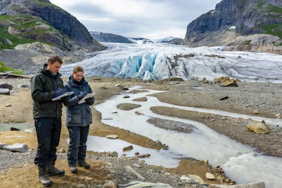
Two field observers with notebooks looking across a braided glacial meltwater stream toward the crevassed snout of a Norwegian valley glacier
Field Safety Note

Observing Snouts & Ice Portals Safely

Never approach the vertical ice front or step inside subglacial meltwater tunnels (breportaler). Outlet tongues flow continuously even when their terminus is retreating; sudden block calving and roof collapses happen without warning in every season, and subglacial water pockets can burst out into the forefield.
Reading the Forefield

Clues Carved into Bedrock and Sediment

As you walk the trail approaching a glacier snout—such as the 45-minute walk along Nigardsbrevatnet or up toward Steindalsbreen in Lyngen—you pass through a chronological museum of subglacial mechanics.

Abrasion & Quarrying

Roches Moutonnées (Rundsva)

Look at the profile of bedrock bosses in the valley floor. The up-valley side facing the glacier is ground smooth and gently rounded by ice pressure; the down-valley side is steep, jagged, and stepped where meltwater refroze in joints and plucked blocks away.

Micro-Scale Marks

Striations & Chattermarks

Pour a splash of water from your bottle onto a smooth bedrock slab to increase contrast. Parallel scratches (skuringsstriper) show the exact line of ice motion, while crescent-shaped fractures (sigdbrudd) record boulders chattering under immense basal load.

Subglacial Water

Potholes (Jettegryter)

Pressurised meltwater plunging down moulins or rushing beneath the ice spins cobbles in bedrock eddies, drilling cylindrical shafts several metres deep. You can examine dry subglacial potholes high on valley walls at Sohlbergplassen or along Rullestadjuvet.

Historical Timeline

Walking Across the Post-1750 Retreat Sequence

Most Norwegian glaciers melted away completely during the mid-Holocene climatic optimum (~7,000 to 5,000 years ago) before reforming as temperatures cooled. They reached their greatest historical extent during the Little Ice Age around AD 1748–1750.

  • The 1750 Outer Terminal Moraine Often located 2 to 4 kilometres down-valley from today’s ice front. In Jostedalen, the 1748 advance crushed several valley farms before halting. Today, this outer ridge is covered in mature birch trees, crowberry heath, and large crustose lichens exceeding 120 mm in diameter.
  • The 1925–1930 Recessional Ridges Smaller nested boulder ridges marking brief winter readvances or standstills during the early twentieth century. Vegetation here is thinner—dominated by pioneer willow shrubs, heather, and medium-sized map lichens.
  • The 1990s Coastal Readvance Marker Unlike Alpine glaciers in central Europe, maritime western Norwegian outlets (such as Briksdalsbreen and Nigardsbreen) briefly advanced by several hundred metres between 1989 and 1999 due to winter North Atlantic Oscillation snow surpluses, leaving fresh, bare gravel ridges before resuming rapid 21st-century retreat.