The Caledonian Paradox
Why Harder, Older Rock Caps the Summits
In undisturbed sedimentary basins, the oldest rocks sit at the bottom and younger layers rest on top. Across vast tracts of southern and central Norway—most visibly on Hardangervidda, in Valdres, and around the fringes of Jotunheimen—this order is reversed.
Between 490 and 400 million years ago, the ancient continent Laurentia (Greenland and North America) collided with Baltica (Scandinavia), closing the Iapetus Ocean. As the Himalayan-scale Caledonian mountain chain rose, enormous slabs of deep crustal rock—called thrust sheets or nappes (skyvedekker)—were detached and shoved hundreds of kilometres southeastward over soft Cambrian and Ordovician shales and limestones.
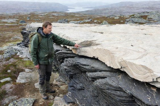
Walk up the trail toward Hårteigen (1,690 m) on Hardangervidda or look at Hallingskarvet from Ustaoset. At the base, you walk over dark, flaky phyllite and mica schist—metamorphosed seafloor muds that weather into fertile, moisture-holding soils. Above a sharp horizontal line on the cliff face sits a sheer cap of massive Precambrian granite and gneiss. That contact line is the mylonite thrust zone where one continent rode over another.
Field Clue • Thrust Boundary
How to Spot a Mylonite Zone
Where a heavy nappe slid across underlying beds, intense shear stress ground the mineral grains into a fine, ribbon-banded rock called mylonite. Look for a distinct horizontal ledge, a line of groundwater seepage, and sudden changes in vegetation from lime-loving flowers below to acid-tolerant lichens above.